Microwave data assimilation improves forecasts of hurricane intensity, rainfall
 February 1, 2022, by Matthew Carroll
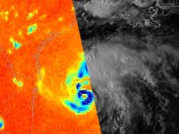
Image: Microwave brightness temperature on top of visible reflectance for Hurricane Harvey before its landfall in Texas. Credit: Penn State . All Rights Reserved.
UNIVERSITY PARK, Pa. — In 2017, Hurricane Harvey stalled after making landfall over coastal Texas, pouring down record rainfall, flooding communities and becoming one of the wettest and most destructive storms in United States history. A new technique using readily available data reduces forecast errors and could improve track, intensity and rainfall forecasts for future storms like Hurricane Harvey, according to Penn State scientists.
“Our study indicates that avenues exist for producing more accurate forecasts for tropical cyclones using available yet underutilized data,” said Yunji Zhang, assistant research professor in the Department of Meteorology and Atmospheric Science at Penn State. “This could lead to better warnings and preparedness for tropical cyclone-associated hazards in the future.”
For the full story, please visit Penn State News.
