Before the Storm: How Supercomputers Can Provide Better Weather and Tornado Forecasts
Before the Storm: How Supercomputers Can Provide Better Weather and Tornado Forecasts
ARTICLE May 14, 2019 | by Linda Barney

Credit: Yunji (Jerry) Zhang, Penn State University
A significant volume of deaths and property loss is associated with severe thunderstorms and related phenomena including tornadoes and hail, and other natural disasters like hurricanes, droughts, and flash floods. The advanced warning processes of tornadic thunderstorms have the shortest time span compared with other weather hazards, usually from minutes to hours. The current average warning lead time of tornadoes is less than 20 minutes. An extension of warning lead time as small as one minute could make a considerable difference in events like tornadoes.
Researchers now have a new tool to aid in weather and tornado forecasting. In 2016, the National Oceanic and Atmospheric Administration (NOAA) launched the first of the newest-generation geostationary weather satellites, GOES-16, which is designed to send high-resolution, high-frequency and high-accuracy images from its Advanced Baseline Imager (ABI) instrument. GOES-16 provides a full disk image of the Earth every 15 minutes, and one focusing on the continental U.S. every five minutes at the same time.
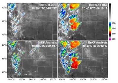
A team of Pennsylvania State University researchers are the first to directly use the satellite radiance data from the GOES-16 satellite in numerical models designed to forecast tornadic thunderstorms, which cause 17 percent of all severe weather deaths in the United States. The team, led by Dr. Fuqing Zhang, Distinguished Professor of Pennsylvania State University, and Director of the Penn State Center for Advanced Data Assimilation and Predictability Techniques, perform research that has the potential to provide earlier warnings about tornadoes to help save lives and improve safety during extreme weather events. “There is a huge amount of data that is generated during our tornadic thunderstorm research. A single forecast can contain up to tens of terabytes of data that is either ingested from the satellite or generated by the numerical model. Our work requires using a supercomputer to perform the simulations, and to analyze and archive the data,” states Zhang.
Read the full article:
Before the Storm: How Supercomputers Can Provide Better Weather and Tornado Forecasts
